Displaying 41 to 45 of 45

Census 2011 - Open Atlas Project - Key Statistics information for districts
Tue, 12 Feb 2013 08:50
Alex Singleton, Lecturer in Geography at the University of Liverpool has mapped every Census Key Statistic at output area (OA) level for every local authority in England and Wales.
"Almost every non count variable (apart from Hectares) was mapped from the Key Statistics data disseminated by Nomis, and...

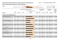
Community Based Survey Results 2012/13 Q2
Fri, 01 Feb 2013 14:24
Leicestershire County Council and Leicestershire Police Authority have jointly commissioned the Community Based Survey, which replaces the previous community safety CRAVE Survey. The project combines key survey requirements of the County Council and Police Authority together into one consultation. As...
Community Based Survey Results 2012/13 Q3
Fri, 01 Feb 2013 14:17
Leicestershire County Council and Leicestershire Police Authority have jointly commissioned the Community Based Survey, which replaces the previous community safety CRAVE Survey. The project combines key survey requirements of the County Council and Police Authority together into one consultation. As...

Crime Reduction Dashboards (December 2012)
Thu, 31 Jan 2013 10:25
The Crime Reduction Dashboards provide a visual indication of recorded crime figures against performance/reduction targets for the year-to-date. All seven districts of Leicestershire are covered along with Leicester City, and an overall view of Leicestershire and the Force Area.
For more information,...

Unemployment Bulletin December 2012
Wed, 23 Jan 2013
The JSA claimant data in this bulletin is available down to ward level. The JSA data is also available broken down by the detailed ethnic groups down to Local Authority level.
The population figures used to calculate residence-based proportions (rates) have changed from working age (16-59f/64m) to aged...