Displaying 1 to 40 of 94

2001 Census Output Area Classifications
Fri, 03 Oct 2008 14:52
The 2001 Area Classifications were created on behalf of the Office of National Statistics by the University of Leeds. The classification is used to group together geographic areas according to key characteristics common to the population in that grouping. These groupings are called clusters, and are...
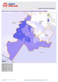
Active People KPI1 small area estimates for Blaby
Mon, 10 Dec 2007 14:24
The Active People Survey is the largest ever survey of sport and active recreation to be undertaken by Sport England in Europe. Key Performance Indicator (KPI) #1 is the numbers of people participating moderately in physical activity for thirty minutes three times a week. This thematic map of Blaby district...

Active People KPI1 small area estimates for Charnwood
Mon, 10 Dec 2007 14:22
The Active People Survey is the largest ever survey of sport and active recreation to be undertaken by Sport England in Europe. Key Performance Indicator (KPI) #1 is the numbers of people participating moderately in physical activity for thirty minutes three times a week. This thematic map of the Charnwood...

Active People KPI1 small area estimates for Harborough
Mon, 10 Dec 2007 14:21
The Active People Survey is the largest ever survey of sport and active recreation to be undertaken by Sport England in Europe. Key Performance Indicator (KPI) #1 is the numbers of people participating moderately in physical activity for thirty minutes three times a week. This thematic map of the Harborough...

Active People KPI1 small area estimates for Hinckley and Bosworth
Mon, 10 Dec 2007 14:19
The Active People Survey is the largest ever survey of sport and active recreation to be undertaken by Sport England in Europe. Key Performance Indicator (KPI) #1 is the numbers of people participating moderately in physical activity for thirty minutes three times a week. This thematic map of Hinckley...

Active People KPI1 small area estimates for Leicester
Mon, 10 Dec 2007 14:14
The Active People Survey is the largest ever survey of sport and active recreation to be undertaken by Sport England in Europe. Key Performance Indicator (KPI) #1 is the numbers of people participating moderately in physical activity for thirty minutes three times a week. This thematic map of Leicester...

Active People KPI1 small area estimates for Melton
Mon, 10 Dec 2007 14:20
The Active People Survey is the largest ever survey of sport and active recreation to be undertaken by Sport England in Europe. Key Performance Indicator (KPI) #1 is the numbers of people participating moderately in physical activity for thirty minutes three times a week. This thematic map of the Melton...

Active People KPI1 small area estimates for North West Leicestershire
Mon, 10 Dec 2007 14:23
The Active People Survey is the largest ever survey of sport and active recreation to be undertaken by Sport England in Europe. Key Performance Indicator (KPI) #1 is the numbers of people participating moderately in physical activity for thirty minutes three times a week. This thematic map of North West...

Active People KPI1 small area estimates for Oadby and Wigston
Mon, 10 Dec 2007 14:22
The Active People Survey is the largest ever survey of sport and active recreation to be undertaken by Sport England in Europe. Key Performance Indicator (KPI) #1 is the numbers of people participating moderately in physical activity for thirty minutes three times a week. This thematic map of Oadby and...
Blaby Community Safety Partnership : Evidence Base Summary 2008
Tue, 02 Dec 2008 13:38
This Community Safety Partnership Evidence Base Summary summarises the findings of the Leicestershire Community Safety Partnership Strategic Assessment 2008 for the Blaby Community Safety Partnership.
For more information, please contact:
Karen Earp
Research and Insight Officer
Research and Insight Team...

Blaby CSP Strategic Assessment 2007
Fri, 18 Jan 2008 16:38
The Partnership Strategic Assessment provides knowledge and understanding of community safety problems that will inform and enable partners to develop their Community Safety Plan 2008-11

Blaby Priority Neighbourhood Profile: Central Enderby
Wed, 13 Feb 2008 09:57
The Blaby Priority Neighbourhood Profile for Central Enderby is now available. This profile provides a comprehensive overview of the Central Enderby intervention and monitoring areas. The report covers a range of useful baseline statistics for the area including information on demographics, deprivation,...

Bluetooth proximity marketing campaign - Coalville Town Centre
Thu, 18 Dec 2008 10:14
This report provides an overview and analysis of a collaborative project by Leicestershire Drug and Alcohol Action Team (DAAT), Leicestershire County Council, North West Leicestershire Partnership in Safer Communities, Hinckley and Bosworth Community Safety Partnership and Leicestershire Police to pilot...

Bluetooth proximity marketing campaign - Hinckley Town Centre
Thu, 18 Dec 2008 09:49
This report provides an overview and analysis of a collaborative project by Leicestershire Drug and Alcohol Action Team (DAAT), Leicestershire County Council, Hinckley and Bosworth Community Safety Partnership, North West Leicestershire Partnership in Safer Communities and Leicestershire Police to pilot...

Charnwood Community Safety Partnership : Evidence Base Summary 2008
Tue, 02 Dec 2008 13:39
This Community Safety Partnership Evidence Base Summary summarises the findings of the Leicestershire Community Safety Partnership Strategic Assessment 2008 for the Charnwood Community Safety Partnership.
For more information, please contact:
Karen Earp
Research and Insight Officer
Research and Insight Team...

Charnwood CSP Strategic Assessment 2007
Mon, 25 Feb 2008 08:44
The Partnership Strategic Assessment provides knowledge and understanding of community safety problems that will inform and enable partners to develop their Community Safety Plan 2008-11

Charnwood Priority Neighbourhood Profile: Loughborough East
Mon, 17 Sep 2007 07:27
The Charnwood Priority Neighbourhood Profile for Loughborough East is now available...
The Charnwood Priority Neighbourhood Profile for Loughborough East is now available. This profile provides a comprehensive overview of the Loughborough East priority neighbourhood. The report covers a range of useful...

Charnwood Priority Neighbourhood Profile: Loughborough West
Fri, 14 Dec 2007 16:08
The Charnwood Priority Neighbourhood Profile for Loughborough West is now available. This profile provides a comprehensive overview of the Loughborough West intervention and monitoring areas. The report covers a range of useful baseline statistics for the area including information on demographics, deprivation,...

Charnwood Priority Neighbourhood Profile: Mountsorrel
Fri, 14 Dec 2007 15:52
The Charnwood Priority Neighbourhood Profile for Mountsorrel is now available. This profile provides a comprehensive overview of the Mountsorrel intervention and monitoring areas. The report covers a range of useful baseline statistics for the area including information on demographics, deprivation,...

Charnwood Priority Neighbourhood Profile: Syston
Tue, 22 Jan 2008 15:35
The Charnwood Priority Neighbourhood Profile for Syston is now available. This profile provides a high level overview of the Syston intervention area. The report covers a range of useful baseline statistics for the area including information on demographics, deprivation, crime, economy, health, children...
Charnwood Priority Neighbourhood Profile: Thurmaston
Fri, 14 Dec 2007 16:13
The Charnwood Priority Neighbourhood Profile for Thurmaston is now available. This profile provides a comprehensive overview of the Thurmaston intervention and monitoring areas. The report covers a range of useful baseline statistics for the area including information on demographics, deprivation, crime,...

Cohesive Communities in Leicestershire
Mon, 30 Jul 2007 08:16
This report was produced by the Research and Information Team at Leicestershire County Council and provides an overview and analysis of the issues around community cohesion in Leicestershire.
The report will contribute towards the evidence base for a Sustainable Community Strategy and will also along...

Credit Crunch Report December 2008
Fri, 19 Dec 2008
This report, to be produced monthly, uses a range of information to assess the local impact of the credit crunch in the context of the national economic downturn. The report uses local datasets such as claimant data, housing sales and business optimism. Each month new data will be included to monitor...

Deprivation Change in Leicestershire Priority Neighbourhoods
Tue, 10 Jun 2008 09:37
This report examines the change in IMD (Indices of Multiple Deprivation) ranking between 2004 and 2007 within LAA Priority Neighbourhoods. The document provides an outline to the process of identifying Priority Neighbourhoods and the role played by IMD in the initial work as well as an overview of the...

Education, Skills and Training in Leicestershire
Fri, 24 Oct 2008 10:11
This report provides an analysis of the Education, Skills and Training domain within the Indices of Deprivation (2007). This domain meaures both young people's education and adult skills. The analysis explores comparisons with IMD2004 and links to other related domains and datasets at Lower Super Output...
Employment Land Availability Report 2008
Tue, 09 Dec 2008 11:50
The Annual Employment Land Availability Report contains information on employment land supply, availability and development in Leicester, Leicestershire and Rutland. The latest report, covering the year to 31st March 2008, has been published. Land availability and development are measured against the...

Harborough Community Safety Partnership : Evidence Base Summary 2008
Tue, 02 Dec 2008 13:40
This Community Safety Partnership Evidence Base Summary summarises the findings of the Leicestershire Community Safety Partnership Strategic Assessment 2008 for the Harborough Community Safety Partnership.
For more information, please contact:
Karen Earp
Research and Insight Officer
Research and Insight...

Harborough CSP Strategic Assessment 2007
Fri, 18 Jan 2008 16:31
The Partnership Strategic Assessment provides knowledge and understanding of community safety problems that will inform and enable partners to develop their Community Safety Plan 2008-11

Hinckley & Bosworth CSP Strategic Assessment
Mon, 25 Feb 2008 08:50
The Partnership Strategic Assessment provides knowledge and understanding of community safety problems that will inform and enable partners to develop their Community Safety Plan 2008-11

Hinckley and Bosworth Community Safety Partnership : Evidence Base Summary 2008
Tue, 02 Dec 2008 13:40
This Community Safety Partnership Evidence Base Summary summarises the findings of the Leicestershire Community Safety Partnership Strategic Assessment 2008 for the Hinckley and Bosworth Community Safety Partnership.
For more information, please contact:
Karen Earp
Research and Insight Officer
Research and...

Hinckley and Bosworth Neighbourhood Profile: Bagworth and Thornton
Wed, 09 Jan 2008 15:52
The Hinckley and Bosworth Priority Neighbourhood Profile for Bagworth and Thornton is now available. This profile provides a comprehensive overview of the Bagworth and Thornton intervention area. The report covers a range of useful baseline statistics for the area including information on demographics,...

Hinckley and Bosworth Neighbourhood Profile: Barwell
Mon, 02 Jul 2007 09:19
The Hinckley and Bosworth Priority Neighbourhood Profile for Barwell is now available...
The Hinckley and Bosworth Priority Neighbourhood Profile for Barwell is now available. This profile provides a comprehensive overview of the Barwell intervention and monitoring areas. The report covers a range of...

Hinckley and Bosworth Neighbourhood Profile: Burbage St. Catherine's
Wed, 13 Feb 2008 15:14
The Hinckley and Bosworth Priority Neighbourhood Profile for Burbage St. Catherine's is now available. This profile provides a comprehensive overview of the Burbage St. Catherine's intervention and monitoring areas. The report covers a range of useful baseline statistics for the area including information...

Hinckley and Bosworth Neighbourhood Profile: Earl Shilton
Mon, 02 Jul 2007 08:48
The Earl Shilton Neighbourhood Profile is now available...
The Hinckley and Bosworth Priority Neighbourhood Profile for Earl Shilton is now available. This profile provides a comprehensive overview of the Earl Shilton intervention and monitoring areas. The report covers a range of useful baseline statistics...
Hinckley and Bosworth Neighbourhood Profile: Hinckley Trinity West (Zone 1)
Tue, 18 Dec 2007 11:43
Description: The Hinckley and Bosworth Priority Neighbourhood Profile for Hinckley Trinity West (Hinckley Zone 1) is now available. This profile provides a comprehensive overview of the Hinckley Trinity West intervention and monitoring areas. The report covers a range of useful baseline statistics for...

Hinckley and Bosworth Neighbourhood Profile: Hinckley Westfield Junior School (Hinckley Zone 2)
Tue, 18 Dec 2007 10:17
The Hinckley and Bosworth Priority Neighbourhood Profile for Hinckley Westfield Junior School (Hinckley Zone 2) is now available. This profile provides a comprehensive overview of the Hinckley Westfield Junior School intervention and monitoring areas. The report covers a range of useful baseline statistics...

Income Deprivation Affecting Children in Leicestershire
Thu, 09 Oct 2008 09:45
The Indices of Deprivation 2007 (ID2007) is the collective name given to seven indices and two supplementary indices which are used to measure deprivation across England. The ID2007 are some of the most widely used data sets by local authorities to understand their communities and prioritise resources....

Indices of Deprivation 2004 - Key Findings
Thu, 01 Nov 2007
The Indices of Deprivation 2004 are produced by the Office of the Deputy Prime Minister (ODPM). They are an attempt to measure deprivation in a consistent way for small areas across England. The following documents cover the individual districts of Leicestershire and Leicestershire county as a whole....

Indices of Deprivation 2007 - Leicestershire Headline Results
Wed, 16 Jan 2008 15:59
The Indices of Deprivation – Leicestershire Headlines Results, report is divided into two parts. The first deals with interpretation of the index at county, unitary and local authority level, and the second analyses the index at the local area (lower super output area) level for both the combined...

Key results from the Leicestershire Indices of Deprivation 2007
Sat, 27 Sep 2008 17:24
This report provides a more detailed analysis of overall deprivation in Leicestershire than the headline deprivation results released by the research team in January 2007. The new Index of Multiple Deprivation 2007 (IMD 2007) is one of the most widely used data sets by local authorities to understand...