Displaying 241 to 280 of 616

Unemployment Bulletin September 2011
Wed, 12 Oct 2011
The JSA claimant data in this bulletin is available down to ward level. The JSA data is also available broken down by the detailed ethnic groups down to Local Authority level.
The population figures used to calculate residence-based proportions (rates) have changed from working age (16-59f/64m) to aged...

Report : Anti-Social Behaviour Dashboard (September 2011)
Tue, 08 Nov 2011 12:50
The Anti-Social Behaviour (ASB) Dashboard provides a visual indication of the number of recorded ASB incidents against the previous year-to-date and long-term average. ASB incidents are broken down into three categories: personal, nuisance and environmental. All seven districts of Leicestershire are...

Report : Crime Reduction Dashboards (September 2011)
Tue, 08 Nov 2011 12:52
The Crime Reduction Dashboards provide a visual indication of recorded crime figures against performance/reduction targets for the year-to-date. All seven districts of Leicestershire are covered along with Leicester City, and an overall view of Leicestershire and the Force Area. The local reduction targets...

Unemployment Bulletin October 2011
Wed, 16 Nov 2011
The JSA claimant data in this bulletin is available down to ward level. The JSA data is also available broken down by the detailed ethnic groups down to Local Authority level.
The population figures used to calculate residence-based proportions (rates) have changed from working age (16-59f/64m) to aged...

Hate Incident Monitoring Project Dashboard
Tue, 22 Nov 2011 14:11
The Hate Incident Monitoring Project Dashboard provides a quarterly summary of the number of hate incidents reported to the Police and to the HIMP (and Leicestershire Schools - Quarter 4 only). The dashboard provides an indication of the progress towards the target to increase the reporting of hate incidents...

Crime Reduction Dashboards (October 2011)
Thu, 24 Nov 2011 17:07
The Crime Reduction Dashboards provide a visual indication of recorded crime figures against performance/reduction targets for the year-to-date. All seven districts of Leicestershire are covered along with Leicester City, and an overall view of Leicestershire and the Force Area.
For more information,...

Anti-Social Behaviour Dashboard (October 2011)
Fri, 25 Nov 2011 11:52
The Anti-Social Behaviour (ASB) Dashboard provides a visual indication of the number of recorded ASB incidents against the previous year-to-date and long-term average. ASB incidents are broken down into three categories: personal, nuisance and environmental. All seven districts of Leicestershire are...

Community Based Survey Results 2011/12 Q2
Thu, 01 Dec 2011 16:11
Leicestershire County Council and Leicestershire Police Authority have jointly commissioned the Community Based Survey, which replaces the previous community safety CRAVE Survey. The project combines key survey requirements of the County Council and Police Authority together into one consultation. As...
Leicestershire County Council Green Spaces Consultation Report
Tue, 06 Dec 2011 15:36
Early in 2011, the county council asked the public to say which local green spaces they particularly valued and why. This was in response to Government proposals to create a new designation, to protect green areas of particular importance to local communities.
A key aim of the green spaces consultation...

Unemployment Bulletin November 2011
Wed, 14 Dec 2011
The JSA claimant data in this bulletin is available down to ward level. The JSA data is also available broken down by the detailed ethnic groups down to Local Authority level.
The population figures used to calculate residence-based proportions (rates) have changed from working age (16-59f/64m) to aged...

Green Spaces Consultation - Forum Reports
Tue, 20 Dec 2011 15:36
The Government stated, in the Coalition Agreement, its intention to create a new designation to protect green areas of particular importance to local communities. Understanding which green spaces local people particularly value, and why, will help local communities and councils decide where new homes...

Blaby Green Spaces Consultation Reports
Tue, 20 Dec 2011 16:01
The Government stated, in the Coalition Agreement, its intention to create a new designation to protect green areas of particular importance to local communities. Understanding which green spaces local people particularly value, and why, will help local communities and councils decide where new homes...

Charnwood Green Spaces Consultation Reports
Tue, 20 Dec 2011 16:08
The Government stated, in the Coalition Agreement, its intention to create a new designation to protect green areas of particular importance to local communities. Understanding which green spaces local people particularly value, and why, will help local communities and councils decide where new homes...

Harborough Green Spaces Consultation Reports
Tue, 20 Dec 2011 16:08
The Government stated, in the Coalition Agreement, its intention to create a new designation to protect green areas of particular importance to local communities. Understanding which green spaces local people particularly value, and why, will help local communities and councils decide where new homes...

Hinckley & Bosworth Green Spaces Consultation Reports
Tue, 20 Dec 2011 16:09
The Government stated, in the Coalition Agreement, its intention to create a new designation to protect green areas of particular importance to local communities. Understanding which green spaces local people particularly value, and why, will help local communities and councils decide where new homes...

Melton Green Spaces Consultation Reports
Tue, 20 Dec 2011 16:09
The Government stated, in the Coalition Agreement, its intention to create a new designation to protect green areas of particular importance to local communities. Understanding which green spaces local people particularly value, and why, will help local communities and councils decide where new homes...

North West Leicestershire Green Spaces Consultation Reports
Tue, 20 Dec 2011 16:10
The Government stated, in the Coalition Agreement, its intention to create a new designation to protect green areas of particular importance to local communities. Understanding which green spaces local people particularly value, and why, will help local communities and councils decide where new homes...

Oadby & Wigston Green Spaces Consultation Reports
Tue, 20 Dec 2011 16:10
The Government stated, in the Coalition Agreement, its intention to create a new designation to protect green areas of particular importance to local communities. Understanding which green spaces local people particularly value, and why, will help local communities and councils decide where new homes...

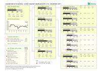
Crime Reduction Dashboards (November 2011)
Thu, 12 Jan 2012 09:06
The Crime Reduction Dashboards provide a visual indication of recorded crime figures against performance/reduction targets for the year-to-date. All seven districts of Leicestershire are covered along with Leicester City, and an overall view of Leicestershire and the Force Area.
For more information,...
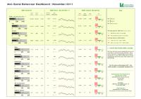
Anti-Social Behaviour Dashboard (November 2011)
Thu, 12 Jan 2012 09:27
The Anti-Social Behaviour (ASB) Dashboard provides a visual indication of the number of recorded ASB incidents against the previous year-to-date and long-term average. ASB incidents are broken down into three categories: personal, nuisance and environmental. All seven districts of Leicestershire are...

Unemployment Bulletin December 2011
Wed, 18 Jan 2012
The JSA claimant data in this bulletin is available down to ward level. The JSA data is also available broken down by the detailed ethnic groups down to Local Authority level.
The population figures used to calculate residence-based proportions (rates) have changed from working age (16-59f/64m) to aged...
Crime Reduction Dashboards (December 2011)
Fri, 27 Jan 2012 09:38
The Crime Reduction Dashboards provide a visual indication of recorded crime figures against performance/reduction targets for the year-to-date. All seven districts of Leicestershire are covered along with Leicester City, and an overall view of Leicestershire and the Force Area.
For more information,...

Anti-Social Behaviour Dashboard (December 2011)
Fri, 27 Jan 2012 09:47
The Anti-Social Behaviour (ASB) Dashboard provides a visual indication of the number of recorded ASB incidents against the previous year-to-date and long-term average. ASB incidents are broken down into three categories: personal, nuisance and environmental. All seven districts of Leicestershire are...

Domestic Abuse Dashboard : Quarter 3 2011/12
Fri, 27 Jan 2012 10:03
The Domestic Abuse Dashboard provides a visual indication of recorded offences and non-recordable incidents of domestic abuse reported to the Police in Leicestershire County for the current year-to-date compared to the same period last year. Figures are provided for all seven districts of Leicestershire....

Community Based Survey Results 2011/12 Q3
Mon, 13 Feb 2012 08:59
Leicestershire County Council and Leicestershire Police Authority have jointly commissioned the Community Based Survey, which replaces the previous community safety CRAVE Survey. The project combines key survey requirements of the County Council and Police Authority together into one consultation. As...
Unemployment Bulletin January 2012
Mon, 20 Feb 2012
The JSA claimant data in this bulletin is available down to ward level. The JSA data is also available broken down by the detailed ethnic groups down to Local Authority level.
The population figures used to calculate residence-based proportions (rates) have changed from working age (16-59f/64m) to aged...

Crime Reduction Dashboards (January 2012)
Fri, 24 Feb 2012 11:09
The Crime Reduction Dashboards provide a visual indication of recorded crime figures against performance/reduction targets for the year-to-date. All seven districts of Leicestershire are covered along with Leicester City, and an overall view of Leicestershire and the Force Area.
For more information,...
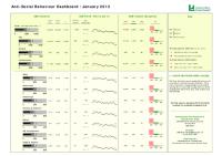
Anti-Social Behaviour Dashboard (January 2012)
Fri, 24 Feb 2012 11:34
The Anti-Social Behaviour (ASB) Dashboard provides a visual indication of the number of recorded ASB incidents against the previous year-to-date and long-term average. ASB incidents are broken down into three categories: personal, nuisance and environmental. All seven districts of Leicestershire are...

Oadby & Wigston Community Safety Partnership Strategic Assessment 2011
Mon, 12 Mar 2012 15:26
The Partnership Strategic assessment is a statutory document produced annually to inform Community Safety Partnerships about crime, disorder and community safety issues in their area. The aim of this Strategic assessment is to provide Community Safety Partnerships with a comprehensive analysis of crime,...

Safer North West Partnership Strategic Assessment 2011
Mon, 12 Mar 2012 15:51
The Partnership Strategic Assessment (PSA) is a statutory document produced annually to inform Community Safety Partnerships about crime, disorder and community safety issues in their area. The aim of this Strategic assessment is to provide Community Safety Partnerships with a comprehensive analysis...

Melton Community Safety Partnership Strategic Assessment 2011
Tue, 13 Mar 2012 14:27
The Partnership Strategic Assessment (PSA) is a statutory document produced annually to inform Community Safety Partnerships about crime, disorder and community safety issues in their area. The aim of this Strategic assessment is to provide Community Safety Partnerships with a comprehensive analysis...

Unemployment Bulletin February 2012
Wed, 14 Mar 2012
The JSA claimant data in this bulletin is available down to ward level. The JSA data is also available broken down by the detailed ethnic groups down to Local Authority level.
The population figures used to calculate residence-based proportions (rates) have changed from working age (16-59f/64m) to aged...

Blaby Community Safety Partnership Strategic Assessment 2011
Tue, 03 Apr 2012 12:12
The Partnership Strategic Assessment (PSA) is a statutory document produced annually to inform Community Safety Partnerships about crime, disorder and community safety issues in their area. The aim of this Strategic assessment is to provide Community Safety Partnerships with a comprehensive analysis...

Community Based Survey Results 2011/12 Q4
Wed, 04 Apr 2012 08:48
Leicestershire County Council and Leicestershire Police Authority have jointly commissioned the Community Based Survey, which replaces the previous community safety CRAVE Survey. The project combines key survey requirements of the County Council and Police Authority together into one consultation. As...

Crime Reduction Dashboards (February 2012)
Wed, 11 Apr 2012 09:10
The Crime Reduction Dashboards provide a visual indication of recorded crime figures against performance/reduction targets for the year-to-date. All seven districts of Leicestershire are covered along with Leicester City, and an overall view of Leicestershire and the Force Area.
For more information,...

Anti-Social Behaviour Dashboard (February 2012)
Wed, 11 Apr 2012 09:34
The Anti-Social Behaviour (ASB) Dashboard provides a visual indication of the number of recorded ASB incidents against the previous year-to-date and long-term average. ASB incidents are broken down into three categories: personal, nuisance and environmental. All seven districts of Leicestershire are...

Harborough Community Safety Partnership Strategic Assessment 2011
Mon, 16 Apr 2012 11:41
The Partnership Strategic Assessment (PSA) is a statutory document produced annually to inform Community Safety Partnerships about crime, disorder and community safety issues in their area. The aim of this Strategic assessment is to provide Community Safety Partnerships with a comprehensive analysis...

Charnwood Community Safety Partnership Strategic Assessment 2011
Mon, 16 Apr 2012 11:50
The Partnership Strategic Assessment (PSA) is a statutory document produced annually to inform Community Safety Partnerships about crime, disorder and community safety issues in their area. The aim of this Strategic assessment is to provide Community Safety Partnerships with a comprehensive analysis...

Hinckley & Bosworth Community Safety Partnership Strategic Assessment 2011
Tue, 17 Apr 2012 14:02
The Partnership Strategic Assessment (PSA) is a statutory document produced annually to inform Community Safety Partnerships about crime, disorder and community safety issues in their area. The aim of this Strategic assessment is to provide Community Safety Partnerships with a comprehensive analysis...

Unemployment Bulletin March 2012
Wed, 18 Apr 2012
The JSA claimant data in this bulletin is available down to ward level. The JSA data is also available broken down by the detailed ethnic groups down to Local Authority level.
The population figures used to calculate residence-based proportions (rates) have changed from working age (16-59f/64m) to aged...