Displaying 1 to 40 of 67

Anti-Social Behaviour Dashboard (December 2010)
Fri, 28 Jan 2011 10:48
The Anti-Social Behaviour (ASB) Dashboard provides a visual indication of the number of recorded ASB incidents against the previous year-to-date targets and long-term average. ASB incidents are broken down by category: Rowdy or Inconsiderate Behaviour, Vehicle Nuisance and Inappropriate Behaviour, Hoax...
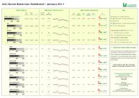
Anti-Social Behaviour Dashboard (January 2011)
Tue, 01 Mar 2011 09:27
The Anti-Social Behaviour (ASB) Dashboard provides a visual indication of the number of recorded ASB incidents against the previous year-to-date targets and long-term average. ASB incidents are broken down by category: Rowdy or Inconsiderate Behaviour, Vehicle Nuisance and Inappropriate Behaviour, Hoax...

Anti-Social Behaviour Dashboard (March 2011)
Tue, 26 Apr 2011 17:35
The Anti-Social Behaviour (ASB) Dashboard provides a visual indication of the number of recorded ASB incidents against the previous year-to-date targets and long-term average. ASB incidents are broken down by category: Rowdy or Inconsiderate Behaviour, Vehicle Nuisance and Inappropriate Behaviour, Hoax...

Anti-Social Behaviour Dashboard (May 2011)
Fri, 15 Jul 2011 15:00
The Anti-Social Behaviour (ASB) Dashboard provides a visual indication of the number of recorded ASB incidents against the previous year-to-date and long-term average. ASB incidents are broken down into three categories: personal, nuisance and environmental. All seven districts of Leicestershire are...

Anti-Social Behaviour Dashboard (November 2010)
Mon, 10 Jan 2011 14:58
The Anti-Social Behaviour (ASB) Dashboard provides a visual indication of the number of recorded ASB incidents against the previous year-to-date targets and long-term average. ASB incidents are broken down by category: Rowdy or Inconsiderate Behaviour, Vehicle Nuisance and Inappropriate Behaviour, Hoax...

Anti-Social Behaviour Dashboard (October 2011)
Fri, 25 Nov 2011 11:52
The Anti-Social Behaviour (ASB) Dashboard provides a visual indication of the number of recorded ASB incidents against the previous year-to-date and long-term average. ASB incidents are broken down into three categories: personal, nuisance and environmental. All seven districts of Leicestershire are...

Blaby Electoral Division Profiles - Census 2001 Key Statistics
Mon, 31 Jan 2005 15:45
Following the recent boundary changes in Leicestershire these area profiles provides a summary of the key data for each of the eight Electoral Divisions in Blaby, using the 2001 Census.

Blaby Green Spaces Consultation Reports
Tue, 20 Dec 2011 16:01
The Government stated, in the Coalition Agreement, its intention to create a new designation to protect green areas of particular importance to local communities. Understanding which green spaces local people particularly value, and why, will help local communities and councils decide where new homes...

Blaby Parish Profiles - Census 2001
Mon, 31 Jan 2005 15:45
Simple 'Profiles' containing around 100 variables have been created for all Parishes in Blaby with at least 50 residents and 20 households. The themes covered are: People; Households; Work & Qualifications and Accommodation & Tenure. These profiles have not been released for higher geographies,...

Blaby Ward Profiles - Census 2001
Mon, 31 Jan 2005 15:45
1)The profiles below provide a summary of all the main Census topics for each ward in the District. The profiles have been compiled using the Key Statistics Tables series released by the Office of National Statistics in 2003 and also provide comparison figures for the District and County areas.
Please...

Charnwood Electoral Division Profiles - Census 2001 Key Statistics
Mon, 31 Jan 2005 15:45
Following the recent boundary changes in Leicestershire, these area profiles provides a summary of the key data for an Electoral Division using the 2001 Census.

Charnwood Green Spaces Consultation Reports
Tue, 20 Dec 2011 16:08
The Government stated, in the Coalition Agreement, its intention to create a new designation to protect green areas of particular importance to local communities. Understanding which green spaces local people particularly value, and why, will help local communities and councils decide where new homes...

Charnwood Parish Profiles - Census 2001
Mon, 31 Jan 2005 15:45
Simple 'Profiles' containing around 100 variables have been created for all Parishes in Leicestershire with at least 50 residents and 20 households. The themes covered are: People; Households; Work & Qualifications and Accommodation & Tenure. These profiles have not been released for higher geographies,...

Charnwood Ward Profiles - Census 2001
Mon, 31 Jan 2005 15:45
1)The profiles below provide a summary of all the main Census topics for each ward in the District. The profiles have been compiled using the Key Statistics Tables series released by the Office of National Statistics in 2003 and also provide comparison figures for the District and County areas.
Please...

Community Based Survey Results 2011/12 Q2
Thu, 01 Dec 2011 16:11
Leicestershire County Council and Leicestershire Police Authority have jointly commissioned the Community Based Survey, which replaces the previous community safety CRAVE Survey. The project combines key survey requirements of the County Council and Police Authority together into one consultation. As...

Crime Reduction Dashboards (December 2010)
Thu, 27 Jan 2011 16:50
The Crime Reduction Dashboards provide a visual indication of recorded crime figures against performance/reduction targets for the year-to-date. All seven districts of Leicestershire are covered along with Leicester City, and an overall view of Leicestershire and the Force Area. The local reduction targets...
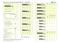
Crime Reduction Dashboards (January 2011)
Tue, 01 Mar 2011 09:14
The Crime Reduction Dashboards provide a visual indication of recorded crime figures against performance/reduction targets for the year-to-date. All seven districts of Leicestershire are covered along with Leicester City, and an overall view of Leicestershire and the Force Area. The local reduction targets...

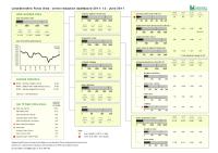
Crime Reduction Dashboards (July 2011)
Fri, 02 Sep 2011 09:18
The Crime Reduction Dashboards provide a visual indication of recorded crime figures against performance/reduction targets for the year-to-date. All seven districts of Leicestershire are covered along with Leicester City, and an overall view of Leicestershire and the Force Area. The local reduction targets...
Crime Reduction Dashboards (June 2011)
Thu, 28 Jul 2011 16:15
The Crime Reduction Dashboards provide a visual indication of recorded crime figures against performance/reduction targets for the year-to-date. All seven districts of Leicestershire are covered along with Leicester City, and an overall view of Leicestershire and the Force Area. The local reduction targets...

Crime Reduction Dashboards (March 2011)
Tue, 26 Apr 2011 17:39
The Crime Reduction Dashboards provide a visual indication of recorded crime figures against performance/reduction targets for the year-to-date. All seven districts of Leicestershire are covered along with Leicester City, and an overall view of Leicestershire and the Force Area. The local reduction targets...

Crime Reduction Dashboards (May 2011)
Fri, 15 Jul 2011 08:53
The Crime Reduction Dashboards provide a visual indication of recorded crime figures against performance/reduction targets for the year-to-date. All seven districts of Leicestershire are covered along with Leicester City, and an overall view of Leicestershire and the Force Area. The local reduction targets...

Crime Reduction Dashboards (November 2010)
Mon, 10 Jan 2011 14:50
The Crime Reduction Dashboards provide a visual indication of recorded crime figures against performance/reduction targets for the year-to-date. All seven districts of Leicestershire are covered along with Leicester City, and an overall view of Leicestershire and the Force Area. The local reduction targets...

Crime Reduction Dashboards (October 2011)
Thu, 24 Nov 2011 17:07
The Crime Reduction Dashboards provide a visual indication of recorded crime figures against performance/reduction targets for the year-to-date. All seven districts of Leicestershire are covered along with Leicester City, and an overall view of Leicestershire and the Force Area.
For more information,...

Green Spaces Consultation - Forum Reports
Tue, 20 Dec 2011 15:36
The Government stated, in the Coalition Agreement, its intention to create a new designation to protect green areas of particular importance to local communities. Understanding which green spaces local people particularly value, and why, will help local communities and councils decide where new homes...

Harborough Electoral Division Profiles - Census 2001 Key Statistics
Mon, 31 Jan 2005 15:45
Following the recent boundary changes in Leicestershire, these area profiles provides a summary of the key data for an Electoral Division using the 2001 Census.

Harborough Green Spaces Consultation Reports
Tue, 20 Dec 2011 16:08
The Government stated, in the Coalition Agreement, its intention to create a new designation to protect green areas of particular importance to local communities. Understanding which green spaces local people particularly value, and why, will help local communities and councils decide where new homes...

Harborough Parish Profiles - Census 2001
Mon, 31 Jan 2005 15:45
Simple 'Profiles' containing around 100 variables have been created for all Parishes in Leicestershire with at least 50 residents and 20 households. The themes covered are: People; Households; Work & Qualifications and Accommodation & Tenure. These profiles have not been released for higher geographies,...

Harborough Ward Profiles - Census 2001
Mon, 31 Jan 2005 15:45
1)The profiles below provide a summary of all the main Census topics for each ward in the District. The profiles have been compiled using the Key Statistics Tables series released by the Office of National Statistics in 2003 and also provide comparison figures for the District and County areas.
Please...

Hate Incident Monitoring Project Dashboard
Tue, 22 Nov 2011 14:11
The Hate Incident Monitoring Project Dashboard provides a quarterly summary of the number of hate incidents reported to the Police and to the HIMP (and Leicestershire Schools - Quarter 4 only). The dashboard provides an indication of the progress towards the target to increase the reporting of hate incidents...

Hinckley & Bosworth Electoral Division Profiles - Census 2001 Key Statistics
Mon, 31 Jan 2005 15:45
Following the recent boundary changes in Leicestershire, these area profiles provides a summary of the key data for an Electoral Division using the 2001 Census.

Hinckley & Bosworth Green Spaces Consultation Reports
Tue, 20 Dec 2011 16:09
The Government stated, in the Coalition Agreement, its intention to create a new designation to protect green areas of particular importance to local communities. Understanding which green spaces local people particularly value, and why, will help local communities and councils decide where new homes...

Hinckley & Bosworth Parish Profiles - Census 2001
Mon, 31 Jan 2005 15:45
Simple 'Profiles' containing around 100 variables have been created for all Parishes in Leicestershire with at least 50 residents and 20 households. The themes covered are: People; Households; Work & Qualifications and Accommodation & Tenure. These profiles have not been released for higher geographies,...

Hinckley & Bosworth Ward Profiles - Census 2001
Mon, 31 Jan 2005 15:45
1)The profiles below provide a summary of all the main Census topics for each ward in the District. The profiles have been compiled using the Key Statistics Tables series released by the Office of National Statistics in 2003 and also provide comparison figures for the District and County areas.
Please...

Leicester & Leicestershire SHMA Managing and Updating of Data
Wed, 27 Apr 2011 16:50
This project builds on the work in the Leicester & Leicestershire Strategic Housing Market Assessment in 2007/8. It involved engaging with multiple departments across each local authority in order to assess the capacity for collecting, using and maintaining data in relation to the Strategic Housing...

Leicester and Leicestershire Business Survey 2011
Thu, 07 Apr 2011 10:39
The Leicester and Leicestershire Local Enterprise Partnership (LEP) has published the latest edition of the Leicester and Leicestershire Business Survey. The business survey has been carried out by a partnership involving Leicestershire County Council, Leicester City Council and other key local agencies...
Leicester and Leicestershire Economic Assessment 2011
Wed, 14 Sep 2011 15:16
The purpose of a Local Economic Assessment (LEA) is to provide a robust evidence base that will underpin strategic planning, investment decisions and delivery plans. This document is a refresh of LEA work conducted in 2010, providing more recent statistics and adjustments to reflect the changing policy...

Leicester and Leicestershire Housing Requirements Study
Thu, 06 Oct 2011 10:04
Blaby District Council, Charnwood Borough Council, Harborough District Council, Hinckley & Bosworth Borough Council, Melton Borough Council, North West Leicestershire District Council, Oadby & Wigston Borough Council, Leicester City Council and Leicestershire County Council are publishing the...
Leicestershire County Council Green Spaces Consultation Report
Tue, 06 Dec 2011 15:36
Early in 2011, the county council asked the public to say which local green spaces they particularly valued and why. This was in response to Government proposals to create a new designation, to protect green areas of particular importance to local communities.
A key aim of the green spaces consultation...

Melton Electoral Division Profiles - Census 2001 Key Statistics
Mon, 31 Jan 2005 15:45
Following the recent boundary changes in Leicestershire, these area profiles provides a summary of the key data for an Electoral Division using the 2001 Census.
Melton Green Spaces Consultation Reports
Tue, 20 Dec 2011 16:09
The Government stated, in the Coalition Agreement, its intention to create a new designation to protect green areas of particular importance to local communities. Understanding which green spaces local people particularly value, and why, will help local communities and councils decide where new homes...