Displaying 1 to 40 of 89

Blaby Electoral Division Profiles - Census 2001 Key Statistics
Mon, 31 Jan 2005 15:45
Following the recent boundary changes in Leicestershire these area profiles provides a summary of the key data for each of the eight Electoral Divisions in Blaby, using the 2001 Census.

Charnwood Electoral Division Profiles - Census 2001 Key Statistics
Mon, 31 Jan 2005 15:45
Following the recent boundary changes in Leicestershire, these area profiles provides a summary of the key data for an Electoral Division using the 2001 Census.

Blaby Parish Profiles - Census 2001
Mon, 31 Jan 2005 15:45
Simple 'Profiles' containing around 100 variables have been created for all Parishes in Blaby with at least 50 residents and 20 households. The themes covered are: People; Households; Work & Qualifications and Accommodation & Tenure. These profiles have not been released for higher geographies,...

Charnwood Parish Profiles - Census 2001
Mon, 31 Jan 2005 15:45
Simple 'Profiles' containing around 100 variables have been created for all Parishes in Leicestershire with at least 50 residents and 20 households. The themes covered are: People; Households; Work & Qualifications and Accommodation & Tenure. These profiles have not been released for higher geographies,...

Harborough Parish Profiles - Census 2001
Mon, 31 Jan 2005 15:45
Simple 'Profiles' containing around 100 variables have been created for all Parishes in Leicestershire with at least 50 residents and 20 households. The themes covered are: People; Households; Work & Qualifications and Accommodation & Tenure. These profiles have not been released for higher geographies,...

Hinckley & Bosworth Parish Profiles - Census 2001
Mon, 31 Jan 2005 15:45
Simple 'Profiles' containing around 100 variables have been created for all Parishes in Leicestershire with at least 50 residents and 20 households. The themes covered are: People; Households; Work & Qualifications and Accommodation & Tenure. These profiles have not been released for higher geographies,...

Melton Parish Profiles - Census 2001
Mon, 31 Jan 2005 15:45
Simple 'Profiles' containing around 100 variables have been created for all Parishes in Leicestershire with at least 50 residents and 20 households. The themes covered are: People; Households; Work & Qualifications and Accommodation & Tenure. These profiles have not been released for higher geographies,...

North West Leicestershire Parish Profiles - Census 2001
Mon, 31 Jan 2005 15:45
Simple 'Profiles' containing around 100 variables have been created for all Parishes in Leicestershire with at least 50 residents and 20 households. The themes covered are: People; Households; Work & Qualifications and Accommodation & Tenure. These profiles have not been released for higher geographies,...

Harborough Electoral Division Profiles - Census 2001 Key Statistics
Mon, 31 Jan 2005 15:45
Following the recent boundary changes in Leicestershire, these area profiles provides a summary of the key data for an Electoral Division using the 2001 Census.

Hinckley & Bosworth Electoral Division Profiles - Census 2001 Key Statistics
Mon, 31 Jan 2005 15:45
Following the recent boundary changes in Leicestershire, these area profiles provides a summary of the key data for an Electoral Division using the 2001 Census.

Melton Electoral Division Profiles - Census 2001 Key Statistics
Mon, 31 Jan 2005 15:45
Following the recent boundary changes in Leicestershire, these area profiles provides a summary of the key data for an Electoral Division using the 2001 Census.

NW Leicestershire Electoral Division Profiles - Census 2001 Key Statistics
Mon, 31 Jan 2005 15:45
Following the recent boundary changes in Leicestershire, these area profiles provides a summary of the key data for an Electoral Division using the 2001 Census.

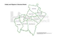
Oadby & Wigston Electoral Division Profiles - Census 2001 Key Statistics
Mon, 31 Jan 2005 15:45
Following the recent boundary changes in Leicestershire these area profiles provides a summary of the key data for the four Oadby & Wigston Electoral Divisions, using the 2001 Census.

Charnwood Ward Profiles - Census 2001
Mon, 31 Jan 2005 15:45
1)The profiles below provide a summary of all the main Census topics for each ward in the District. The profiles have been compiled using the Key Statistics Tables series released by the Office of National Statistics in 2003 and also provide comparison figures for the District and County areas.
Please...

Harborough Ward Profiles - Census 2001
Mon, 31 Jan 2005 15:45
1)The profiles below provide a summary of all the main Census topics for each ward in the District. The profiles have been compiled using the Key Statistics Tables series released by the Office of National Statistics in 2003 and also provide comparison figures for the District and County areas.
Please...

Hinckley & Bosworth Ward Profiles - Census 2001
Mon, 31 Jan 2005 15:45
1)The profiles below provide a summary of all the main Census topics for each ward in the District. The profiles have been compiled using the Key Statistics Tables series released by the Office of National Statistics in 2003 and also provide comparison figures for the District and County areas.
Please...

Melton Ward Profiles - Census 2001
Mon, 31 Jan 2005 15:45
1)The profiles below provide a summary of all the main Census topics for each ward in the District. The profiles have been compiled using the Key Statistics Tables series released by the Office of National Statistics in 2003 and also provide comparison figures for the District and County areas.
Please...

North West Leicestershire Ward Profiles - Census 2001
Mon, 31 Jan 2005 15:45
1)The profiles below provide a summary of all the main Census topics for each ward in the District. The profiles have been compiled using the Key Statistics Tables series released by the Office of National Statistics in 2003 and also provide comparison figures for the District and County areas.
Please...
Oadby & Wigston Ward Profiles - Census 2001
Mon, 31 Jan 2005 15:45
1)The profiles below provide a summary of all the main Census topics for each ward in the District. The profiles have been compiled using the Key Statistics Tables series released by the Office of National Statistics in 2003 and also provide comparison figures for the District and County areas.
Please...

Blaby Ward Profiles - Census 2001
Mon, 31 Jan 2005 15:45
1)The profiles below provide a summary of all the main Census topics for each ward in the District. The profiles have been compiled using the Key Statistics Tables series released by the Office of National Statistics in 2003 and also provide comparison figures for the District and County areas.
Please...

District Area Profiles - Census 2001 Key Statistics
Sun, 01 Jan 2006
The 24 tables cover the main Census topics and consist of approximately 375 counts. These tables are resently available only at local authority district,county, unitary, regional and national level. These area profiles provides a summary of key data for Leicestershire Districts,County, East Midlands...

District Community Profiles 2005
Wed, 01 Nov 2006
These community profiles for the seven districts contains a range of data from a variety of sources and considers all aspects of the local community. They include chapters on crime, health, ethnicity, deprivation, education and the local economy.

Population Estimates Trends Updated to 2010
Tue, 02 Aug 2011 10:28
The Office for National Statistics (ONS) estimate of the mid-2010 population for Leicestershire is 648,700, and Leicester 306,600, with the Leicestershire and Leicester sub-region about 955,400 in estimated population. Office for National Statistics (ONS) published mid-2010 population estimates on 30th...

Overseas migrant worker inflows to 2010
Thu, 11 Aug 2011 17:58
New registrations for National Insurance numbers by overseas nationals give an indication of the number of overseas workers in residence here for more than a year. The total number registering from January to December 2010 was over 7,000 in Leicester City and over 2,000 in Leicestershire County. The...

Leicestershire County Council Green Spaces Consultation Report
Tue, 06 Dec 2011 15:36
Early in 2011, the county council asked the public to say which local green spaces they particularly valued and why. This was in response to Government proposals to create a new designation, to protect green areas of particular importance to local communities.
A key aim of the green spaces consultation...

Green Spaces Consultation - Forum Reports
Tue, 20 Dec 2011 15:36
The Government stated, in the Coalition Agreement, its intention to create a new designation to protect green areas of particular importance to local communities. Understanding which green spaces local people particularly value, and why, will help local communities and councils decide where new homes...

Blaby Green Spaces Consultation Reports
Tue, 20 Dec 2011 16:01
The Government stated, in the Coalition Agreement, its intention to create a new designation to protect green areas of particular importance to local communities. Understanding which green spaces local people particularly value, and why, will help local communities and councils decide where new homes...

Charnwood Green Spaces Consultation Reports
Tue, 20 Dec 2011 16:08
The Government stated, in the Coalition Agreement, its intention to create a new designation to protect green areas of particular importance to local communities. Understanding which green spaces local people particularly value, and why, will help local communities and councils decide where new homes...

Harborough Green Spaces Consultation Reports
Tue, 20 Dec 2011 16:08
The Government stated, in the Coalition Agreement, its intention to create a new designation to protect green areas of particular importance to local communities. Understanding which green spaces local people particularly value, and why, will help local communities and councils decide where new homes...

Hinckley & Bosworth Green Spaces Consultation Reports
Tue, 20 Dec 2011 16:09
The Government stated, in the Coalition Agreement, its intention to create a new designation to protect green areas of particular importance to local communities. Understanding which green spaces local people particularly value, and why, will help local communities and councils decide where new homes...

Melton Green Spaces Consultation Reports
Tue, 20 Dec 2011 16:09
The Government stated, in the Coalition Agreement, its intention to create a new designation to protect green areas of particular importance to local communities. Understanding which green spaces local people particularly value, and why, will help local communities and councils decide where new homes...

North West Leicestershire Green Spaces Consultation Reports
Tue, 20 Dec 2011 16:10
The Government stated, in the Coalition Agreement, its intention to create a new designation to protect green areas of particular importance to local communities. Understanding which green spaces local people particularly value, and why, will help local communities and councils decide where new homes...

Oadby & Wigston Green Spaces Consultation Reports
Tue, 20 Dec 2011 16:10
The Government stated, in the Coalition Agreement, its intention to create a new designation to protect green areas of particular importance to local communities. Understanding which green spaces local people particularly value, and why, will help local communities and councils decide where new homes...

Census 2011 - First Release
Mon, 23 Jul 2012 13:01
On 16th July 2012 the Office of National Statistics published the first of four Census releases. This first release contains detail on:
• Sex and age (at 5 year bands) of the population
• Number of households
• Population estimates (residents and those living in communal establishments)...
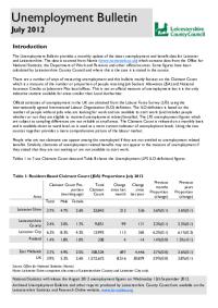
Unemployment Bulletin July 2012
Wed, 29 Aug 2012
The JSA claimant data in this bulletin is available down to ward level. The JSA data is also available broken down by the detailed ethnic groups down to Local Authority level.
The population figures used to calculate residence-based proportions (rates) have changed from working age (16-59f/64m) to aged...

Unemployment Bulletin August 2012
Wed, 12 Sep 2012
The JSA claimant data in this bulletin is available down to ward level. The JSA data is also available broken down by the detailed ethnic groups down to Local Authority level.
The population figures used to calculate residence-based proportions (rates) have changed from working age (16-59f/64m) to aged...
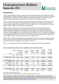
Unemployment Bulletin September 2012
Wed, 17 Oct 2012
The JSA claimant data in this bulletin is available down to ward level. The JSA data is also available broken down by the detailed ethnic groups down to Local Authority level.
The population figures used to calculate residence-based proportions (rates) have changed from working age (16-59f/64m) to aged...

Unemployment Bulletin October 2012
Wed, 14 Nov 2012
The JSA claimant data in this bulletin is available down to ward level. The JSA data is also available broken down by the detailed ethnic groups down to Local Authority level.
The population figures used to calculate residence-based proportions (rates) have changed from working age (16-59f/64m) to aged...

Unemployment Bulletin November 2012
Wed, 12 Dec 2012
The JSA claimant data in this bulletin is available down to ward level. The JSA data is also available broken down by the detailed ethnic groups down to Local Authority level.
The population figures used to calculate residence-based proportions (rates) have changed from working age (16-59f/64m) to aged...

Unemployment Bulletin December 2012
Wed, 23 Jan 2013
The JSA claimant data in this bulletin is available down to ward level. The JSA data is also available broken down by the detailed ethnic groups down to Local Authority level.
The population figures used to calculate residence-based proportions (rates) have changed from working age (16-59f/64m) to aged...