Displaying 1 to 40 of 115

Blaby Electoral Division Profiles - Census 2001 Key Statistics
Mon, 31 Jan 2005 15:45
Following the recent boundary changes in Leicestershire these area profiles provides a summary of the key data for each of the eight Electoral Divisions in Blaby, using the 2001 Census.

Blaby Green Spaces Consultation Reports
Tue, 20 Dec 2011 16:01
The Government stated, in the Coalition Agreement, its intention to create a new designation to protect green areas of particular importance to local communities. Understanding which green spaces local people particularly value, and why, will help local communities and councils decide where new homes...

Blaby Parish Profiles - Census 2001
Mon, 31 Jan 2005 15:45
Simple 'Profiles' containing around 100 variables have been created for all Parishes in Blaby with at least 50 residents and 20 households. The themes covered are: People; Households; Work & Qualifications and Accommodation & Tenure. These profiles have not been released for higher geographies,...

Blaby Ward Profiles - Census 2001
Mon, 31 Jan 2005 15:45
1)The profiles below provide a summary of all the main Census topics for each ward in the District. The profiles have been compiled using the Key Statistics Tables series released by the Office of National Statistics in 2003 and also provide comparison figures for the District and County areas.
Please...

Census 2011 - Transport
Mon, 23 Sep 2013 16:00
On January 30th, 2013, ONS released a range of data from the 2011 Census at a small area level. The report and interactive dashboards below analyse data from the two transport-related census questions:
- Car and Van Availability
- Method of Travel to work
The first dashboard presents data from both questions...

Charnwood Electoral Division Profiles - Census 2001 Key Statistics
Mon, 31 Jan 2005 15:45
Following the recent boundary changes in Leicestershire, these area profiles provides a summary of the key data for an Electoral Division using the 2001 Census.

Charnwood Green Spaces Consultation Reports
Tue, 20 Dec 2011 16:08
The Government stated, in the Coalition Agreement, its intention to create a new designation to protect green areas of particular importance to local communities. Understanding which green spaces local people particularly value, and why, will help local communities and councils decide where new homes...

Charnwood Parish Profiles - Census 2001
Mon, 31 Jan 2005 15:45
Simple 'Profiles' containing around 100 variables have been created for all Parishes in Leicestershire with at least 50 residents and 20 households. The themes covered are: People; Households; Work & Qualifications and Accommodation & Tenure. These profiles have not been released for higher geographies,...

Charnwood Ward Profiles - Census 2001
Mon, 31 Jan 2005 15:45
1)The profiles below provide a summary of all the main Census topics for each ward in the District. The profiles have been compiled using the Key Statistics Tables series released by the Office of National Statistics in 2003 and also provide comparison figures for the District and County areas.
Please...

Children & Families Performance Dashboards Q1 2017-18
Mon, 11 Sep 2017
Leicestershire County Council - Children & Families Performance Dashboards Q1 2017-18.
The dashboard and associated report provide an update on the performance of Leicestershire County Council's Children & Families Department. The dashboard covers children's social care services (including child...

Children & Families Performance Report Q1 2017-18
Mon, 11 Sep 2017
Leicestershire County Council - Children & Families Performance Report Q1 2017-18.
The report and associated dashboard provide an update on the performance of Leicestershire County Council's Children & Families Department. The report covers children's social care services (including child protection,...

Deprivation Change in Leicestershire Priority Neighbourhoods
Tue, 10 Jun 2008 09:37
This report examines the change in IMD (Indices of Multiple Deprivation) ranking between 2004 and 2007 within LAA Priority Neighbourhoods. The document provides an outline to the process of identifying Priority Neighbourhoods and the role played by IMD in the initial work as well as an overview of the...

Director of Public Health Annual Report 2013
Mon, 03 Feb 2014
This is the last in a series of three reports from Leicestershire's Director of Public Health reviewing health across the life cycle. This report focuses on the health and wellbeing of working age adults. Earlier reports focussed on the health of children and the health of older people.
This report is...

Director of Public Health Annual Report 2014, Data Appendix
Mon, 24 Nov 2014
Leicestershire Public Health
All the data included in the annual report for 2014 is available in this data visualisation.
The tab across the top allows you to examine the "key facts", recommendations of the repot and data in each chapter. In each chapter tab, multiple indicators which relate to the chapter subject area can be examined...

Reports from the Director of Public Health.

District Area Profiles - Census 2001 Key Statistics
Sun, 01 Jan 2006
The 24 tables cover the main Census topics and consist of approximately 375 counts. These tables are resently available only at local authority district,county, unitary, regional and national level. These area profiles provides a summary of key data for Leicestershire Districts,County, East Midlands...

District Community Profiles 2005
Wed, 01 Nov 2006
These community profiles for the seven districts contains a range of data from a variety of sources and considers all aspects of the local community. They include chapters on crime, health, ethnicity, deprivation, education and the local economy.

Education, Skills and Training in Leicestershire
Fri, 24 Oct 2008 10:11
This report provides an analysis of the Education, Skills and Training domain within the Indices of Deprivation (2007). This domain meaures both young people's education and adult skills. The analysis explores comparisons with IMD2004 and links to other related domains and datasets at Lower Super Output...
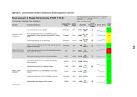
Environment & Transport Performance Report Q1 2017-18
Thu, 07 Sep 2017
Leicestershire County Council - Environment & Transport Performance Report Q1 207-18.
The report and associated dashboard/s provide an update on the performance of Leicestershire County Council's Environment & Transport Department. The report covers: waste management; the Council's environmental...
Environment & Transport Performance Report Q1 2017-18 Appendix A-B
Thu, 07 Sep 2017
Leicestershire County Council - Performance Dashboards Q1 2017-18 Appendix A-B.
The dashboard/s and associated report provide an update on the performance of Leicestershire County Council's Environment & Transport Department. The dashboard covers: waste management; the Council's environmental
impact...

There was a comprehensive insight gathering exercise carried out between April and October 2011. These various pieces of research fed into the design phase of the Families with Complex Needs programme which formed part of the National Troubled Families agenda.
The aim of the insight phase was to ensure...
Green Spaces Consultation - Forum Reports
Tue, 20 Dec 2011 15:36
The Government stated, in the Coalition Agreement, its intention to create a new designation to protect green areas of particular importance to local communities. Understanding which green spaces local people particularly value, and why, will help local communities and councils decide where new homes...

Harborough Electoral Division Profiles - Census 2001 Key Statistics
Mon, 31 Jan 2005 15:45
Following the recent boundary changes in Leicestershire, these area profiles provides a summary of the key data for an Electoral Division using the 2001 Census.

Harborough Green Spaces Consultation Reports
Tue, 20 Dec 2011 16:08
The Government stated, in the Coalition Agreement, its intention to create a new designation to protect green areas of particular importance to local communities. Understanding which green spaces local people particularly value, and why, will help local communities and councils decide where new homes...

Harborough Parish Profiles - Census 2001
Mon, 31 Jan 2005 15:45
Simple 'Profiles' containing around 100 variables have been created for all Parishes in Leicestershire with at least 50 residents and 20 households. The themes covered are: People; Households; Work & Qualifications and Accommodation & Tenure. These profiles have not been released for higher geographies,...

Harborough Ward Profiles - Census 2001
Mon, 31 Jan 2005 15:45
1)The profiles below provide a summary of all the main Census topics for each ward in the District. The profiles have been compiled using the Key Statistics Tables series released by the Office of National Statistics in 2003 and also provide comparison figures for the District and County areas.
Please...

Hinckley & Bosworth Electoral Division Profiles - Census 2001 Key Statistics
Mon, 31 Jan 2005 15:45
Following the recent boundary changes in Leicestershire, these area profiles provides a summary of the key data for an Electoral Division using the 2001 Census.

Hinckley & Bosworth Green Spaces Consultation Reports
Tue, 20 Dec 2011 16:09
The Government stated, in the Coalition Agreement, its intention to create a new designation to protect green areas of particular importance to local communities. Understanding which green spaces local people particularly value, and why, will help local communities and councils decide where new homes...

Hinckley & Bosworth Parish Profiles - Census 2001
Mon, 31 Jan 2005 15:45
Simple 'Profiles' containing around 100 variables have been created for all Parishes in Leicestershire with at least 50 residents and 20 households. The themes covered are: People; Households; Work & Qualifications and Accommodation & Tenure. These profiles have not been released for higher geographies,...

Hinckley & Bosworth Ward Profiles - Census 2001
Mon, 31 Jan 2005 15:45
1)The profiles below provide a summary of all the main Census topics for each ward in the District. The profiles have been compiled using the Key Statistics Tables series released by the Office of National Statistics in 2003 and also provide comparison figures for the District and County areas.
Please...

Income Deprivation Affecting Children in Leicestershire
Thu, 09 Oct 2008 09:45
The Indices of Deprivation 2007 (ID2007) is the collective name given to seven indices and two supplementary indices which are used to measure deprivation across England. The ID2007 are some of the most widely used data sets by local authorities to understand their communities and prioritise resources....

Indices of Deprivation 2004 - Key Findings
Thu, 01 Nov 2007
The Indices of Deprivation 2004 are produced by the Office of the Deputy Prime Minister (ODPM). They are an attempt to measure deprivation in a consistent way for small areas across England. The following documents cover the individual districts of Leicestershire and Leicestershire county as a whole....

Indices of Deprivation 2007 - Leicestershire Headline Results
Wed, 16 Jan 2008 15:59
The Indices of Deprivation – Leicestershire Headlines Results, report is divided into two parts. The first deals with interpretation of the index at county, unitary and local authority level, and the second analyses the index at the local area (lower super output area) level for both the combined...

Indices of Deprivation 2007: Analysis of Employment Domain
Thu, 12 Feb 2009 15:19
This report, forming part of a wider body of work on the IMD 2007, provides an analysis of the Employment domain within the Indices of Deprivation (2007).
This report uses IMD data to help better understand worklessness across Leicestershire. It looks at employment deprivation between and within the county...

Key results from the Leicestershire Indices of Deprivation 2007
Sat, 27 Sep 2008 17:24
This report provides a more detailed analysis of overall deprivation in Leicestershire than the headline deprivation results released by the research team in January 2007. The new Index of Multiple Deprivation 2007 (IMD 2007) is one of the most widely used data sets by local authorities to understand...
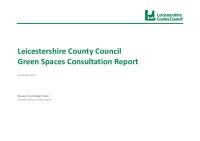
Leicestershire County Council Green Spaces Consultation Report
Tue, 06 Dec 2011 15:36
Early in 2011, the county council asked the public to say which local green spaces they particularly valued and why. This was in response to Government proposals to create a new designation, to protect green areas of particular importance to local communities.
A key aim of the green spaces consultation...

Health and Wellbeing Board's Annual Report updating on progress against the Joint Health and Wellbeing Strategy

Melton Electoral Division Profiles - Census 2001 Key Statistics
Mon, 31 Jan 2005 15:45
Following the recent boundary changes in Leicestershire, these area profiles provides a summary of the key data for an Electoral Division using the 2001 Census.
Melton Green Spaces Consultation Reports
Tue, 20 Dec 2011 16:09
The Government stated, in the Coalition Agreement, its intention to create a new designation to protect green areas of particular importance to local communities. Understanding which green spaces local people particularly value, and why, will help local communities and councils decide where new homes...

Melton Parish Profiles - Census 2001
Mon, 31 Jan 2005 15:45
Simple 'Profiles' containing around 100 variables have been created for all Parishes in Leicestershire with at least 50 residents and 20 households. The themes covered are: People; Households; Work & Qualifications and Accommodation & Tenure. These profiles have not been released for higher geographies,...